
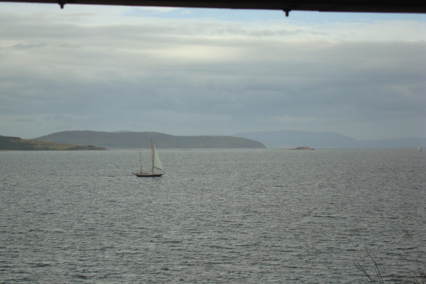
Hobart, Derwent River and Norfolk Bay
Derwent River
The city of Hobart lies on the picturesque Derwent River under the impressive heights of Mount Wellington. Unfortunately the river is heavily polluted as well as having a naturally high level of siltation. The bottom is mostly mud and the visibility poor in the area above the Tasman Bridge. Most people confine their diving to the lower reaches where the river is flushed by fresh ocean water. There is good diving at the mouth of the river. The Tinderbox Peninsula and Betsey Island are unusual for their more substantial volcanic reefs.
Frederick Henry Bay and Norfolk Bay
In the waterways to the east of the city sandstone and other sedimentary rocks are very common. Nice reefs can be found in many parts of Frederick Henry Bay, but Norfolk Bay is generally uninviting. In summary, the area has a number of shallow and easy dives.
The region can become very rough during gales, even in the river, but there is usually a sheltered spot somewhere. Storm Bay and Frederick Henry Bay are very exposed to strong southerly winds and swells.
Services
There are several dive shops and clubs based in the city of Hobart. The city is a major tourist centre and has a wide variety of accommodation from backpacker’s hostels to five star hotels.
Road and Boat Access
There are a number of public boat ramps, with regional outposts being served by major ramps at Tinderbox, South Arm, Lauderdale, Dodges Ferry, Primrose Sands and Dunalley
Hobart Wharves
Rating 4.5 stars, Depth: 6-12 metres Category 2
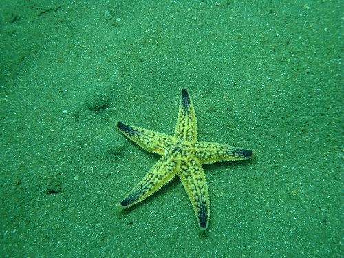
Many people have the impression that the Hobart wharves would be deep and dirty. In actual fact they are well flushed by the ocean tides and within easy diving depths. The attraction here the novelty, it is the sort of dive where you might find anything. The muddy bottom is littered with all sorts of items and there is some interesting marine life. Antique bottles have sunk into the mud and are occasionally uncovered by the wash from ship’s propellers. School fish swim around the piles and starfish and seahorses litter the bottom. An interesting dive to do once when you are getting bored with reef dives. Note the huge concentrations of the Japanese seastar Asterias Amurensis. This starfish was introduced in ship’s water ballast and has taken over the bottom stripping it of shellfish and small marine life. Don’t go from this site straight to another diving area. Your wet gear could contain spores of the starfish and infect other areas. Similarly, if you take a boat to the area, don’t travel to a new area and start to drain out the bilge water.
Permission to dive in the wharf area must be obtained from Tasports. They will direct you to a safe area. Entry and exit is either from a boat or from the wharf. A good place to practice your high water entry skills. To exit you will need to find one of the ladders that Tasports provides for their divers. It is very handy to have someone waiting on the wharf with a rope to help with gear.
Wreck of the S.S. “Lake Illawarra”
Rating 6 stars Depth: 24-35 metres Category 2
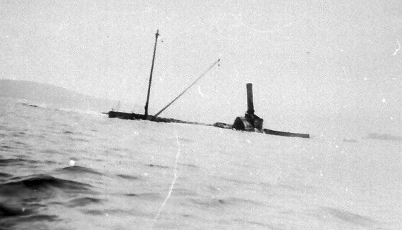
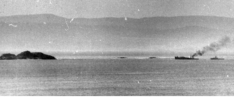
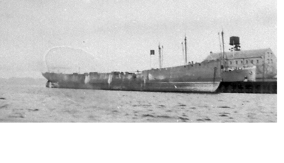
This vessel is easily Tasmania’s largest shipwreck. In January 1975 Captain Pelc was proceeding up the river with a cargo of zinc concentrate. Off Rosny Point he realised that he was approaching the Tasman Bridge too fast and at the wrong angle. He over-corrected and began to head for the mud flats off the Domain. It was too late to make the opening, but he tried again to correct the vessel. This time the loss of speed made her unmanageable. Throwing the engines into full reverse the torque from the propellers threw the ship broadside onto the bridge. Two pylons were shattered and a large section of the bridge fell onto the bow of the vessel. No-one knows exactly how many cars drove off the bridge in the darkness. The captain went into shock and was unable to give orders to the engine room to abandon ship. The chief engineer had to run back to tell them to escape. Within 15 minutes the ship sank, eventually resulting in the deaths of seven crew members. The captain made it to the life raft but could not explain why he had so badly managed his approach to one of the world’s safest harbours. Soon after the inquiry, the papers reported that he had died of ‘a broken heart’.
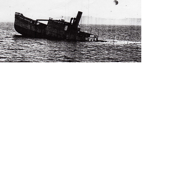
The destruction of the bridge cut the city of Hobart in two and caused immense social dislocation. Salvage divers recovered all the bodies from the wreck and helped themselves to the navigation instruments. The eventual repair of the bridge has made the wreck easy to locate. She lies directly across the new bridge span almost broadside to the bridge, with the bow touching a repaired pontoon. The wreck is covered in jewel anemones and disgusting river mud. The dive should only be attempted by people with recent low visibility experience. It is probably the spookiest dive in Tasmanian waters and divers would be under greater than normal psychological stress.
You must get permission from Tasports before diving the wreck or else you will get a surprise visit from the Police boat. Do not interfere with any of the recording instruments on the bow of the ship. The bow is also cluttered with debris and should be avoided. For a first dive, most would be content to stay around the bridge of the vessel in 24 metres of water. A noon dive in summer on the flood tide after a dry period is more likely to enjoy better visibility. A torch is sometimes not needed as a diffused greenish light penetrates through the silt above. One level down it is much darker, and it is pitch black on the main deck in 30 metres. The bottom is 35 metres deep although the river silt is so thick and runny that it is difficult to tell if you have hit the bottom. Going inside the compartments turns a risky dive into something that is downright dangerous. Only divers with specialist expertise in wreck penetration should attempt this.
Some unpleasant experiences might be had in locating the wreck. It is not uncommon to miss the wreck for the first few dives and land in the hold, or on the bottom. It is better to abort the dive than swim around in the dark not knowing what you have landed in. With practice you will be able to drop the anchor on the bridge every time. The ship’s bridge lies directly off the western-most new pontoon. It is easy to find with a good sounder. There is an excellent model of the wreck in the Tasmanian Museum and Art Gallery.
You will notice that local people are very interested in the wreck. They will often ask if the wreck is likely to move and damage the bridge. One look at the mud will reassure you that the wreck is only going one way, straight down into the ooze. The dive is an unforgettable challenge for experienced divers with an interest in broadening their horizons.
Ship File -”Lake Illawarra”
Built: 1958 Whyalla South Australia
Features: Steel, Steam Turbine-driven bulk carrier of 10383 tons dead-weight
Bellerive Beach
Rating 4 stars Depth: 4-6 metres Category 1
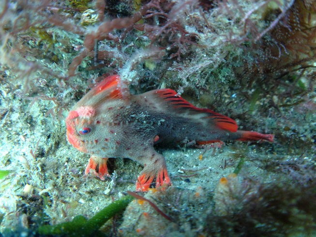
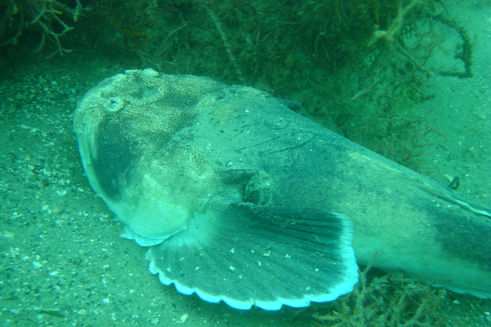
This area is sometimes used by instructors as a training dive. The actual dive is scenically unremarkable. It has an unusually high population of rare Spotted Handfish, but they have suffered from fluctuating fortunes in recent times. This is one of Tasmania’s most unusual animals with its fins half evolved into legs. The fish tends to hop and swim across the bottom ahead of a diver. The fish has struggled due to many factors, but seemed to take a heavy hit with the introduction of Pacific Sea Stars. You must show a dive flag at all times due to the heavy boat traffic in the area.
Droughty Point
Rating 4.5 stars Depth: 2-10 metres Category 2
To the south-east of the city, Droughty Point (pronounced “Droothy” locally) stretches into the Derwent River. This is one of the closest sites to Hobart where it would be possible to find a few crayfish. The water is very shallow close to the south-east point, but the rocks extend well out into the river in about ten metres of water. The bottom is very muddy, but is still covered in some interesting sponge life. The visibility can be very poor. This depends on the amount of silt being washed down the river. Generally high tide produces the clearest conditions in the river. As a scenic dive it is unremarkable, but its proximity to Hobart makes it a popular site. A little further around at Tryworks Point there was once an old whaling station. In addition to this the wreck of the 225 ton wooden barque “Rotuma” lies a little to the south of Tryworks Point. This Norwegian vessel blew ashore in 1907. In both cases little remains, but you never know what you may chance to find. The best boat ramp is at Doran’s Road outside the township of Lauderdale. It is only a short ride to the diving area.
Droughty Point Floating Bridge Section
Rating 4.5 stars Depth: 20 metres Category 4
Prior to the construction of the Tasman Bridge the Derwent was spanned by a floating pontoon bridge. This concrete and steel construction proved to be expensive to maintain and was replaced in the 1960’s. Many of these 580 foot long sections were towed to Droughty Point where they awaited disposal. Most were taken to Betsey Island and scuttled, but this one was scuttled near Droughty Point, close to a deep trench. The western end lies in 28 metres and the eastern end in 22 metres. Having sunk unevenly into the mud the deck is roughly level in 20 metres of water. The dive is popular with police divers, who use it for low visibility training. This will give you some idea that it is not really a scenic dive. The bridge does support some interesting jewel anemones and mud dwelling fish under the pontoons. It is possible to enter the enclosed pontoons through inspection hatches, but this is extremely dangerous. Only divers with extensive experience and a guideline should attempt this. The wreck is marked on navigation charts, but seems closer to Droughty Point than the chart indicates. The bridge can be located with an echo sounder. This is a dive for bored and experienced divers who want something different to do on a slow weekend.
Pigeon Holes
Rating 5 stars Depth: 3 metres Category 1-2
Just north of South Arm lies a sandstone headland called the Pigeon Holes. The bluff gets its name from the unusual effects of erosion on the sandstone. The wind and rain has pitted the surface of the rock making it look like a pigeon loft. The bluff can be accessed by boat. All along the shoreline there are a good variety of fish to be found within easy snorkelling depths. The bottom soon gives out to sand where stingrays and flathead can be seen. There are also some interesting sponges and a good seaweed garden. A very pleasant and convenient dive that would suit most beginners.
Glenvar Beach
Rating 5 stars Depth: 3 metres Category 1-2
At Opossum Bay, the sandstone headland can be accessed from the shore at a beach just to the south of the point. The right of way to the beach is hidden in the suburbs and takes a bit of finding, but this ensures that you will probably have the beach to yourselves. The sandstone sea terrace slopes gently into the water. The reef is a narrow fringe of varies seaweed that quickly gives way to sand. Being so sheltered and shallow its a great beginner dive and a good way to examine the marine life of the Derwent estuary. Many reefs further up the river are badly affected by sediments and invasive species, here there are still plenty of small critters for the observant diver. To enjoy this dive you need to look closely for little critters and take a picture or two. Don’t be surprised to be buzzed by a huge smooth stingray as they are relatively common in this part of the river. Netting bans in the river may have helped there. The ray are quite curious, but are usually not aggressive unless you provoke them.
Iron Pot Reef
Rating 6 stars Depth: 2-15 metres Category 2
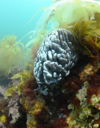
The western side of this reef is very sheltered and the crayfish and fish have suffered accordingly. Boat traffic and nets are the main diving hazards. This part of the reef offers an easy and shallow dive in an attractive weed garden. The iron Pot is patrolled by some inquisitive Leatherjackets and Wrasse and is often visited by school fish. This is the best area to dive during easterly weather. The prettiest diving is on the southern end of the reef, close to the lighthouse. Here there is a small ‘island’ where the sea has split away part of the rock and created a swim-through. This swim-through is colourful and is safe in very calm weather. Further east there is a heavily eroded rock face containing many small caves and crevices in 12 metres. At the base of this wall there a thick sponge garden covered in invertebrate life. This part of the island is very exposed to the prevailing southerly swells. The most obvious feature in the area is the light station which is the oldest operating lighthouse in Australia and was erected in 1832. The remains of an old winch can still be seen on the island. This was used to unload stores for the lighthouse. It was on one of these replenishment voyages that the ketch “Caledonia” was wrecked on the island. This small wooden vessel would have broken up quickly and is unlikely to have left any remains.
Wreck of the S.S. “Lintrose”
Rating 5 stars Depth: 2-5 metres Category 2
Near the Iron Pot lighthouse lie the remains of the S.S. Lintrose. This small river steamer was wrecked in 1932 while carrying a cargo of telegraph poles. This cargo shifted in heavy weather making the vessel unmanageable and she drifted onto the reef. She is located halfway between Iron Pot Island and the next large rock to the north. Little of the wreck remains except for a quantity of steel plate, the motor, and a pair of steel propellers. The site can be located from the surface as it is only in a few metres of water at low tide. The Iron Pot tends to be the main alternative dive when the weather is too rough for Betsey Island. It is a pleasant dive in its own right and it is very easily accessed from the boat ramp at South Arm.
Ship File – “Lintrose”
Built: 1897 by Fleming and Fergusson, Paisley, Scotland.
Dimensions: 126.5 ft x 26 ft x 5.9 ft
Features: Iron twin screw steamer of 148 tons
Betsey Is Wreck Graveyard
Rating 6.5 stars Depth: 20-34 metres Category 2-3
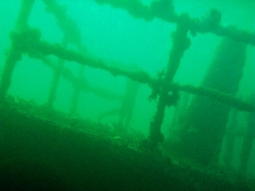
Since 1916, the area to the West of Little Betsey Island has been used for the disposal of unwanted ships. This has created a huge concentration of wreck dives very close to Hobart. The Marine Board has continued to add further vessels to the area and has tried to concentrate them around Little Betsey Island so that they are more accessible to divers. The site has become very popular with divers and charter operators. An echo sounder would be a real bonus in locating the various sites. The wrecks basically consist of two 1930s freighters that are basically flattened and lie off the Little Betsey Reef. A line of 1980s harbour vessels head west from Little Betsey Island. These are in varying states of collapse. Off to the side of these vessels are sections of the old Hobart pontoon bridge.
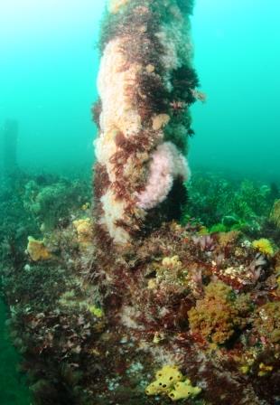
The floating bridge sections and several of the wrecks are covered in massive yellow and white Jewel Anemones. The wrecks can also attracts hordes of school fish from time to time. Most of the wrecks are reasonably safe to enter, except the bridge pontoons. Only experienced dives should attempt an enclosed section and bring torches and a guideline. Most are in around 20 metres , except the “Musgrave” in 34M.
The bottom is a mix of pebble and mud that tends to get very stirred up after bad weather. Even on apparently clear days it can be stirred up by decaying swells from Storm Bay. For this reason the area is not renowned for good visibility. The dive is best left to calm, dry weather and I suspect the ebb rather than the flood will give clearer conditions.
S.S. William Cowper
The hull of this old dredge hopper is flattened, lying west-east about 100 metres to the west of Little Betsey Island. This 170 foot long steel vessel was built in Holland in 1924. She was scuttled in 1979 after failing to win the contract to dump Jarosite waste for the E.Z. Company. She is a vessel of 689 tons.
S.S. Macquarie
This 225 ton steam-driven suction dredge lies some distance from the “William Cowper” with barges and the “Boyer” lying nearby. The 123 foot long hull is intact and the bow points to the north-west. This interesting ship was built in Scotland in 1908 for the Strahan Marine Board. She was designed specifically to dredge the sandbar at Hell’s Gates. After many changes of ownership she was laid up in Prince of Wales Bay. In 1975 she was blown ashore and lay on the rocks until she was refloated and scuttled in 1984.
Barges
Old steel barges were used by the Hobart Tug company to take paper from the A.N.M. mill at Boyer to the Hobart wharves. When A.N.M. changed to road transport the barges became obsolete. Most were scuttled in 1986. One lies close to the bows of the “Macquarie” and another lies only 50 metres away to the south-west, on the way to the “Swiftness”. Most of the barges were 100 feet long and were built for the Army in 1945. There are at least two amongst the flattened wreckage ANM5 & 6. These smaller barges of 74 foot length were built at Hobart in 1960. They were scuttled in 1986 after many years of work for the Department of Construction. These are apparently barges HTL 1,2 & 4.
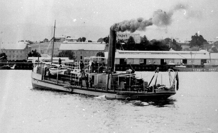
S.S. Swiftness
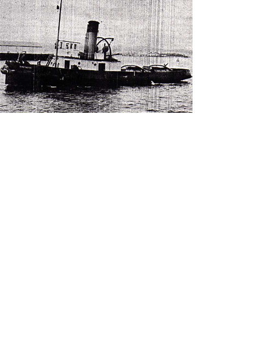
This 147 ton tug lies 100 metres to the south-west of the S.S. Macquarie. She is heavily broken up with only part of the bow and stern remaining intact. Amidships there is a lot of wreckage including an unusual steam engine. This engine was once used in the generating plant of a mainland mine. She was built in Scotland in 1920 and scuttled in 1979. Her steel hull is 98.4 feet long.
Floating Bridge Sections
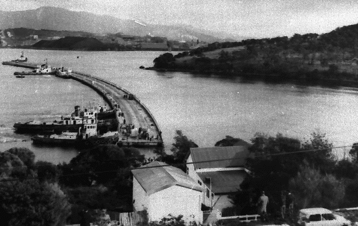
About 100 metres to each side of the main wreck area are two 580 foot long sections of the old Hobart pontoon bridge. All the sections of this concrete bridge are heavily encrusted in anemones. This one is roughly level with the southern end of Big Betsey Island. If you wish to see what they look like on the surface, go to the wharf at Alonnah where one section is still used as a jetty.
S.S. Leura
About 500 metres south-west of the Little Betsey lie the remains of this old freighter. The vessel is heavily broken up with only the two boilers showing up on the sounder. For this reason she can be difficult to locate. This wreck has by far the best fish life. The 1186 ton wreck is 250 feet long and was scuttled in 1934. She was built in Liverpool in 1878.
S.S. Musgrave
This 817 ton freighter is hard to locate and gives a weak trace on the sounder only if you cross the boilers. She is slightly to the west of the “Leura”. The 211 foot long vessel is heavily broken up in the same fashion as the S.S. “Leura”, except for a jewel anemone encrusted stern section with a prominent steering quadrant. She was built at Glasgow in 1883 as the “Fiona” and scuttled in 1930.
 S.S. Amy Louise
This small river steamer is recorded as having been scuttled here in 1916. I have not confirmed this and she has never been found. As she was a wooden vessel of only 36 tons, only the capstan, boiler and engine are likely to be visible (if they were still onboard) and she will be extremely difficult to locate.
S.S. Boyer
This steam turbine driven tug was scuttled here in the 1980s. She lies close to the “Macquarie”. Much of the superstructure has been removed leaving only the intact hull. This small 60 ton vessel was the last working steam vessel to ply the Derwent.
Spectacle Head
Rating 4 stars Depth: 3-8 metres Category 2
The bluff is too steep and slippery to provide direct access, necessitating a long walk from Red Ochre Beach to the site. Less fit parties may wish to make this a snorkel dive. The diving is unspectacular, but interesting enough for a convenient half-day dive. Small reefs extend out from the shore opposite Spectacle Island. The bottom consists chiefly of a brittle mudstone that has been heavily eroded. Further around the point and in deeper water, it is possible to see a few small crayfish and there is much better fish life. There are plenty of tube worms, various corals and sponges to see. Pick a period of calm weather, as the shallows suffers from bad visibility. The site is exposed to adverse southerly weather.
Whale Rock
Rating 5.5 stars Depth: 4-12 metres Category 2
The rock probably gets its name from the fact that it looks like a diving whale from the shore. It is a small wave-swept rock about one kilometre off Spectacle Head. Its proximity to Hobart makes it an easy half-day dive from the boat ramp at Dodges Ferry. A good day must be chosen as the site is exposed to southerly weather and even moderate conditions will significantly reduce the visibility. Close to the rock the water is very shallow and this can be uncomfortable in the swell. The dive becomes a little more pleasant as you venture out into deeper water. There are a few more fish and you are more sheltered from the surge. In about 12 metres there are a few large rocks.
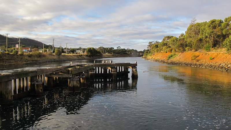
Dunalley (Denison) Canal
Rating 5.5 stars Depth: 10 metres Category 2
This is the only easy drift dive in South-East Tasmania. The Denison Canal was cut through the narrow neck of land at Dunalley around the turn of the century. It was intended to shorten the journey of the small coastal craft that once connected the East coast to Hobart. The canal is still used by small pleasure craft and continues to be maintained by Tasports. If you wish to dive in the canal you must gain permission from the Harbour Master. He will usually require you to provide a manned safety boat. The canal has created an artificial tidal stream and the current can be quite fast. Use the safety boat to pick up divers, or simply swim sideways to the current until the shore is reached. The canal is generally muddy, but is covered in schools of Soldier Fish or mating Spider Crabs. The crabs spawn in the canal and congregate here for a massive ‘orgy’ during the mating season.
Slopin Island Reef
Rating 5 stars Depth: 4-8 metres Category 2
This small island lies close to the north-west side of the Tasman Peninsula and forms part of the Lime Bay Wildlife Reserve. Access to the island is from either Pipe Clay Lagoon or Dunalley. While generally safe, Frederick Henry Bay is still very exposed to southerly weather and a calm day is required. On the south side of the island there is a small reef that offers some shelter from the swell. The reef is about 100 metres long and about 50 metres wide, so there is quite a lot of bottom to cover. The dive is quite attractive with a lot of reef fish and some colourful sponge growths. Apparently there are some very nice shallow reefs in the area between Slopin and the Main. There are also some ruins on the island that date back to the early days of settlement. Only a few traces of the foundations remain.