
Wilsons Promontory
 Eastern Shore
Tin Mine
Cove
3-15M
On Victoria’s exposed coastline you always need an alternative site up your sleeve. It might not be the most adventurous spot, but every dive has some interesting features. Tin Mine Cove has some low rocky reef on a mostly sand bottom. It is easily snorkelled from the nearby camping area, or is reached by boat from Corner Inlet or Port Welshpool. The reef slopes off fairly quickly into 15M about 50M offshore. Further out there is a strong current and this area should be avoided. School fish frequent the area and there are some interesting invertebrates in and around the rocks. A fast current will pick up sediment and reduce visibility, so slack water or a neap tide might be a more rewarding time to dive the area.
Rabbit Island
2-10M
There is easy diving along the northern side with a good mix of habitat types which means different species to see and photograph. The bottom is mostly sandy, but there are also areas of fringing near shore reef and seagrass beds. There is also a surprisingly rich number of school fish including sweep and zebrafish. On the southern side it is slightly deeper with a weedy, rocky bottom. This area has the usual array of shallow reef species such as wrasse, morwong and old wife. The offshore area can be current affected with relatively poor visibility at times, so some caution is required. The shallows are also sometimes affected by surge, particularly on the southern shore.
Sealers Cove
15M
This is an easy and often sheltered site. Along the southern side of the bay there is a fringing reef consisting of a gently sloping boulder field. The usual reef fish can be seen and there is some attractive marine invertebrate growths in the crevices. The site is known for its large populations of boarfish and leatherjackets. The location can get silty and is easily stirred up by bad weather.
Horn Point
20 m
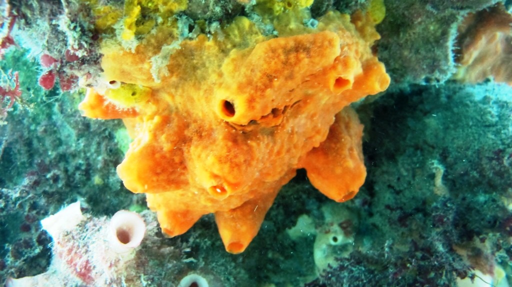
At this site a rocky wall drops into rocky and sandy bottom. The bottom is covered in large sponges, nudibranchs, sea spiders and basket stars. The fish life includes, morwong, leatherjackets, boxfish, old wives and boarfish. Weedy sea dragons, southern coral fish and many other novel species are occasionally encountered.
Refuge Cove
7-20mtrs
This partly sheltered site is an easy and rewarding boat dive. The boulder-strewn north wall is home to thick weed beds patrolled by large numbers of wrasse, boarfish and clouds of barber perch. The area is also often visited by schools of pelagic (ocean roaming) fish.
The southern side is shallower and makes for a good snorkel dive or night dive over the seagrass beds. There is a walking track to the bay from Tidal River and a ranger’s hut.
Bareback Bay
25 m
Bareback Bay is the second bay south of Refuge Cove. A number of interesting granite boulders can be found at the southern end. In the depths they are covered in invertebrates including sponges, ascidian sea squirts, gorgonian sea fans and zoanthid yellow sea daisies. Fish life in the crevices includes bullseyes, blue devilfish and beared cod.
Larkin Cove
10M
The attraction here is some low granite swim-throughs and caves. One found at 7M depth is 12 metres long and a torch is handy for exploring it. The seaweed in the area seems to collect silt which is readily stirred up, but it is generally an easy dive. There is still plenty of the usual reef marine life to see.
Brown Head Pinnacle
21-35M
About 100 metres off the tip of Brown Head, there is a pinnacle of rock coming to within eight metres of the surface. The weed covered shallows peter out at 20M and change into a very spectacular deep sponge garden filled with colourful invertebrate life, patrolled by clouds of Butterfly Perch. The pinnacle starts to level off at 25M into a gently sloping boulder field covered in marine life. This is the sort of dive you can do several times and never get tired of it. All the headlands in the are subject to currents.
Waterloo Bay North Wall
20-40M
The remote dive site is full of granite boulders up to 10m high that provide large swim throughs and overhangs. In the shallow weed beds wrasse, leatherjackets, cuttlefish, draughtboard sharks and blue devilfish are common. In deeper depths large clouds of barber perch and some boarfish hang around near the wall. The rocks are covered in colourful invertebrate life including yellow zoanthids, nudibranchs and sea whips. Seals occasionally visit the site.
Waterloo Pt
20M
For the less experienced divers, or for a second dive, on the south side there is a relatively easy reef dive on a weed-covered bottom. The bottom consists of a gently sloping boulder field with plenty of small crevices to explore. There is a noticeable current towards the point.
Wreck of the “Lady Mildred”
6-25 metres
The 2180 ton, 287.2 ft long steel steam collier “Lady Mildred” was a fairly new vessel having been built at Blyth, England, in 1902. In 1909, the captain completely messed up and ran her ashore in hazy weather one kilometre south of Waterloo Point. The vessel could not be salvaged and quickly broke up. What was left above water was used by the RAAF as a practice target for bombers. Salvors also used explosives on it in the late 1960s. The remaining wrecksite is very scattered, covered in kelp and hard to identify. The wreckage is spread over a 75m x 40m area of granite boulder slope. The wreck lies north-south parallel to a noticeable notch in the cliff that looks like the bow had jammed into the soft rock. The enthusiast will quickly notice an anchor, hawse pipe, bollards and a capstan in the bow area. At the northern end there is an engine, boilers, steering gear and rudder and parts of the hull. The boilers can be hard to find as they have rolled away and are 30metres downslope standing on their ends. There is plenty of fish life to be seen and lots of trenches and swim throughs to poke around in. Visisbility is often good and the site is sheltered from westerly weather.
Lighthouse Landing/South East Point
25-30 m
This dive is on the granite walls north of the lighthouse. The bottom here has granite boulders up to 10M high covered with fish including clouds of butterfly and barber perch. In the shallows near the landing there are apparently fragments of lighthouse supplies that were lost overboard.
Southern and western shore
Fenwick Bight
15-17m
The diving is on a fringe of granite boulders along the shoreline, ending in sand in moderate depths. The eastern end of the bight offers a little shelter and easy diving in good weather, but is still exposed to southerly and south westerly winds. Out toward the point it is a little deeper with vertical walls and interesting small caves. The dive is a good place to see barber perch, boarfish, leatherjackets, sea carp (marblefish) and wrasse.
South Point
5-15m
This is the southern-most point of the Australian mainland. This exposed location offers a shallow bay on the western side that is an easy snorkel or dive on weed-covered boulders. There is much flotsam and shipwreck debris in the area and some interesting small photographic subjects.
Sea Eagle Bay Rocks
35 – 40M
At the northern end of Sea Eagle Bay there is a line of rocks running from the shore. Around the rocks there are large underwater boulders with lots of crevices full of interesting marine life. At 16m on the northern side there is a strange pile of logs, cargo from a shipwreck or a natural collection point for debris? Old wife, sea sweep, wrasse and scalyfin weave about among colourful sponges, sea-squirts and tubeworms.
Oberon Pt / Wreck of the “Hannah Thompson”
The “Hannah Thompson” was a small wooden cutter of 14 tons lost in 1923. The wreck consists of a small amount of iron plate, tubing and bollards in 5-8M among some exposed granite boulders. She lies 200 metres south of Oberon Point. She can be investigated in low seas only and is very exposed to westerly weather. The surrounding rocks also provide some interest.
Norman Pt
5-18m
Norman Point offers an easy snorkel or dive in good weather. Small granite boulders form small caves and crevices before reaching sand a short distance from the shore. There is plenty of fish life as well as small marine invertebrates. The area can be exposed to currents away from the shoreline especially at the tip of the point. The area is a long walk in full scuba gear from the nearest car access point.
Pillar Pt
10-25m
The tip of the point has a large and spectacular granite bommie that lies about 75 metres offshore and rises to within 7 metres of the surface. This bommie lies off a “v”-shaped rock onshore with a large rounded boulder to its right. The deeper sections have very rich and colourful arrays of invertebrates, especially hydroids and anemones. Long-finned pike, magpie perch, wrasse are common. Sea dragons are also sometimes seen. The water shallows closer to the base of the point, but still offers good diving, especially on the southern side. These areas are popular with anglers and fish can be small and timid. This area is close to the Tidal river camp ground although it is still a stiff walk in full scuba gear.
Leonard Pt Bommie
20m
At the tip of the point there are sheer sided granite boulders sitting on sand in 20 metres. The rocks are 8 metres under the surface. This bommie is 100 metres offshore from a pointed rock with a small cave at sea level. Picnic Bay can’t be seen from the bommie. The weed is mainly on the tops of the boulders with the sides encrusted in colourful marine life. Fish life is also good.
Picnic Bay- South end
6m
This is probably more relaxing as a snorkel dive as it involves a stiff walk to the car park. The site is usually very sheltered and offers a wide variety of small fish and invertebrates on small granite boulders at the base of Leonard Point.
Picnic Pt
12mtrs
Whisky Bay car park is about 5-10 km out from Tidal River. It is a straightforward shore dive except for the long walk from the car park. The area offers plenty of small fish and invertebrates on low granite reef.
Tongue Pt
20m
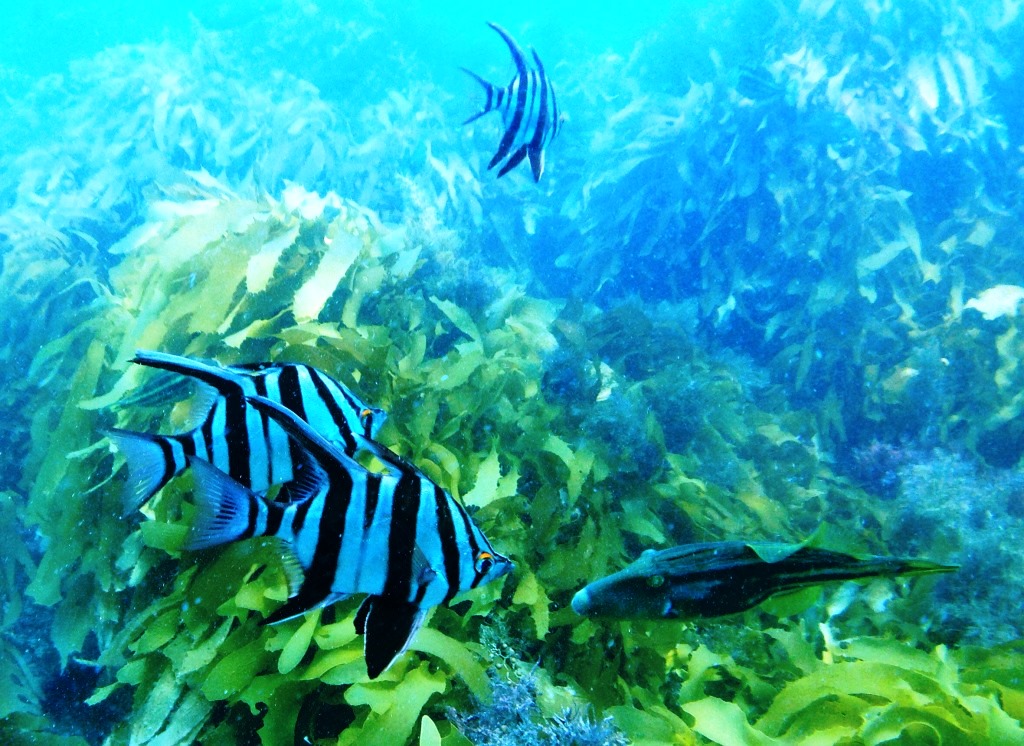
This steep granite reef offers quite a few crevices and narrow swim-throughs. The area between the island and the point is particularly attractive. The area attracts school fish including zebrafish.
Victoria’s Bass Strait Islands
Due to a quirk of history Tasmanian’s ocean jurisdiction is within a few miles of the Victorian coast, although it is rarely visited by Tasmanian divers. Dive site information on the area of Forty Foot Rocks and south is located in the Tasmanian dive guide. The descriptions set out there include Forty Foot Rocks, West Moncoeur Is and Rodondo Is.
Wattle Island
9-35m
Along the north side of the island there is a fringe of shallow reef offering an interesting reef dive going out onto low rock in 18 metres depth. The area is affected by a slight current but this encourages good visibility and an array of colourful invertebrates in the protection of the crevices. The area is patrolled by big schools of butterfly and barber perch.
On the exposed southern side of the island the water is much deeper with great visibility and vertical rock faces plunging into the depths. There are large caves at the base of the cliffs inhabited by a diversity of fishlife. The seaweed grows very deep due to the clear water and the best invertebrate life is along the deep base of the cliffs.
Skull Rock/Cleft Islet
10-40M
This island is part of the Anser Group. It gets its name from the distinctive skull-like shape of the rock. Underwater there are sheer walls into deep water, sometimes strong currents, the odd seal and great fish life. The boulders are covered in sponges, sea whips, zoanthids and gorgonians. There are some large caves, including just to the left of the seal haulout on the north-east side of the rock.
Anser Island
5 – 35M
The sheltered shallow coves on the southern side are often dived and snorkelled. The depth here is rarely deeper than 18m. There is unusual invertebrate marine life here and plenty for the photographer or snorkellor. Small overhangs and caves are home to magpie perch, trumpeter and wrasse. The visibility can be less clear compared to other nearby sites.
The south west side of the island is deeper and there is a small shipwreck scattered down the rocky slope from 3 to 35M. The name of this ‘mystery ship’ is unknown and it may have been an early American whaler or sealer, lost on its way to Melbourne. The remains consist of iron knees, a deck winch, ballast rocks and some other smaller items.
Other parts of Anser Island offer caves and walls covered in jewel anemones, sponges, ascidians and yellow zoanthids.
Kanowna Island
10m-40m
This dive is principally a seal dive with over 2000 fur seals on Kanowna Island. There us a whole days fun just interacting with the seals, but the island also has many beautiful caves and rock walls. The island is very sheer sided and drops to 100M depth a relatively short distance from the shore. As with any seal dive, there is a slightly heightened threat from sharks during the summer pupping season. The area can also be current affected.
Dannevig Island
20-30M
On the north-west end of the island there are huge 8M high granite boulders on a 20 metre deep reef. There are big swim-throughs that can be awkward to swim though in a surgy swell. Large patches of yellow zoanthids are common on the sheltered rock faces. Herring Cale and magpie perch are common. Blue devils are occasionally sighted.
Near the south western end of the island a granite rock can be seen at the surface, spilt by a large crack and lovingly named ‘Bum Rock’. The rock is sheer-sided into 30 metres with the crack cutting ten metres back into the rock. Weed thrives down to 25 metres with the best and most colourful marine life at the base of the rock.
Close to the shore on the north-east tip of the island there is a series of granite formations including bommies in 20 Metres of water that come to within 7 metres of the surface. A ledge in 15 metres fringes the island and that drops down onto big boulders in 30-35 metres of water. There are also large caves and a variety of other spectacular granite formations to explore. The fish life is especially prolific and the marine life in the depths and sheltered cracks is very colourful. This is considered by many to be the best dive on the Prom.
Great Glennie Island
6m -30 m
Half way down the east coast of the island there is shelter from the westerlies and shallow snorkel, or scuba dives. The dive is on seagrass with the hope of seeing slightly different marine creatures than the normal reef dive. Eagles rays, mullet and even seahorses may be seen. Some of the fringing rocky reef along the shore also has interesting small overhangs.
In south westerly weather boats can shelter in the bay at the northern end of Great Glennie Island. It is a mixed sandy/rocky bottom in 18 m. There are various rays and bottom-dwelling small sharks to photograph. Weedy sea dragons are also occasionally encountered. Sea pens are also seen out on the sandy fringes. The bottom can drops to 30 m well way from shore and small boulders attract good fish life.
The nearby Ramsbotham Rocks can also give some shelter from south easterlies and the area has some good boulder bottom and offshore rock spires in the 20 plus metre range. On the eastern side of the rocks the water deepens to 30 metres with excellent deep sponge gardens with plenty of sea pens and sea whips.
Norman Is
30m
The bay on south western Norman Island offers a deeper dive on steep rock walls and large boulder fields. It is very popular in easterlies. The water is so clear that kelp persists to 25 metres but below that the more delicate invertebrate growths are excellent.