

Wreck of the “Macedon”
5M
31 59.4,S 115 32.95E
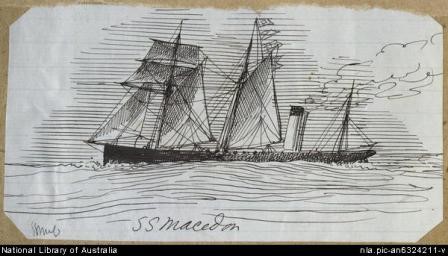
The “Macedon” was an 826 ton iron steamer that struck the West Transit Reef in 1883. She is a relatively intact wreck compared with the “Denton Holme”. To the north west of the wreck there are limestone caves and grottos that are also worthwhile dives. The area has plenty of boat traffic, including the local glass-bottomed boat, so show a dive flag.
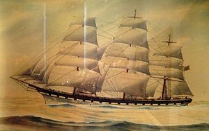
Wreck of the “Denton Holme”
5M
31 59.4,S 115 32.95E or GPS: S 31°59.2700, E 115°33.3300
In 1890, this 998 ton iron sailing ship was loaded up with whiskey, iron pipes, cement and general cargo. Arrived at the island in the evening, requested a pilot, but before receiving one got in too close. Stuck fast it began disintegrating in the swells and broke in two when she struck the same reef as the “Macedon” and almost landed on top of the earlier wreck. She lies 10 or 20M west of the “Macedon”. The wreck’s bow is very close to the surface and a hazard for boat traffic.
The wrecks have been prone to a lot of swell and surge, so there is not a lot left. Don’t tie up to the yellow mooring, as that is used by the glass bottom boat cruises.
Outer Transit Caves
31 59.4S 115 33.2E
This area offers interesting limestone swim-throughs and overhangs packed with colourful invertebrates and good fish life. The visibility if also often very good. There are leatherjackets, scaly fin, truncate coral fish, wrasse, bullseyes and bream. The reef lies not far from the Thompson Bay jetty.
Wreck of the “Uribes”
3M
This 188 ton schooner drifted ashore in 1942 and foundered near the beach. This wreck is almost up on the beach and provides a safe and easy snorkelling experience. The wreck lies along a walking track 1.5km east of the Thompson Bay ferry terminal. Walking from the beach it quickly gives way to a reef platform, then rapidly steps off into deeper water. The area is very protected usually, meaning that this normally fragile wooden wreck is still reasonably intact.
Lady Elizabeth Wreck – Rottnest
8M
GPS: S 32°01.145 E 115°32.872
The “Lady Elizabeth” was a composite (wooden with iron ribs) barque. In 1878 she left Fremantle with sandalwood bound for Shanghai. She then ran aground in a storm off Rottnest Island near Dyer Island. The wreck is located on the south side of Rottnest at Porpoise Bay. It is a sheltered site that is easy to find. Boat owners need to be wary of reefs when entering the area and stay over the areas of sand. She is located on the NW side of Dyer Island behind a ring of limestone reef and adjacent to a big patch of sand. The wreck is visible from the surface with the stern partly buried in the sand and the bow well up in the limestone reef. The site is a jumble of weed-covered debris. The site tends to be a very calm as the outer reef protect it from all but the bigger swells.
Crystal Palace, Dyer Island
GPS: S 32º 01.601, E 115º32.623
8-18M
This rarely dived area is located on the south east side of the Island and is noted for a 600-800m long stretch of caves and swim throughs. Being rarely visited the area has excellent fish life, harlequins, blue groper, samson fish, dhufish, western blue devils, buffalo bream, morwongs, box fish and leatherjackets.
Porpoise Bay Caves – Rottnest
15M
GPS: S 32°01.625, E 115°32.605
Av vis 10M
This pleasant site lies close to the “Crystal Palace” just out of Porpoise Bay. It offers small overhangs and caves packed with marine life.
Parker Point – pocillopora reef
2-12M
The Parker Point area is renowned for a great variety of marine life, both temperate and tropical in very clear waters. The limestone point is the southmost point on Rottnest. The area is relatively exposed to the southwest so can get rough at times, especially further out of the bay. The point itself is ringed with reefs and boat owners need to approach towards the more open eastern shore, but very cautiously. The reef shallows offer some protection from a moderate swell. Here there is the southernmost known outcrop of pocillopora coral, made possible only due to the strong influence of the Leeuwin Current on this part of the island. It is like a piece of the tropics strangely surviving in a temperate weedy reef. Please be careful to avoid anchoring on the reef or accidentally breaking off the corals with your fins.
Parker Point Drop-off – Rottnest
10-22M
GPS: S 32°02.049, E 115°31.346
This drop-off is located on the southern side of Rottnest in a slightly exposed position. The outer drop off can only be dived on very calm days. The reef top is in 4-5M where the swell is often crashing down and potentially dangerous. The shallows drop off onto a more peaceful ledge in 10-12M. The wall created by this ledge can be followed west past numerous gutters, ledges and overhands full of marine life. The area is noted for good fish life buffalo bream, sweetlips, morwongs, squirrel fish, rock cod, wrasse and bullseyes. On the deeper parts there are also attractive sponge gardens.
Salmon Bay
2-3M
The protected bay is on the south side of the island, 4.5 kms from the ferry terminal. At the eastern end there is shallow reef with large sandy expanses. This shallow lagoon provides for easy snorkelling and its best reached by bicycle. Corals grow on limestone ledges packed with small marine life. A good spot for beginners.
Jack’s Patch
32’01.90″ S,115’31.08″ E -about 1/2 mile S/W of Salmon Point
15-27M
A North/ South running strip of limestone reef that has a very good covering of hard and soft corals. Plenty of swim throughs and ledges but only 1 big cave towards the northern end. Shallowest part of the reef is around 13 metres with most of it around the 15-17 metres, it can get a bit deeper towards the southern (27 metres) and western side(22 metres). This dive site supports a very diverse marine ecosystem and a macro phoographers paradise when the vis is great. Not all that good for crayfish.
Cathedral Rocks, Eagle Bay
5M
This area is noted for a collection of large caves and crevices out to seaward of the coastal reef platform. The rocky reef extends well out to sea and has claimed at least one tuna boat. Eagle Bay is the starting point as it offers a sheltered anchorage, but it will take some effort to locate the passage through the ring of sheltering reefs on the eastern side of the bay. Newer divers may prefer a shallow dive in the bay itself, while more experienced parties head out to sea towards the rocks. Just out from the reef platform there is a large rocky outcrop, under that rock is a 10x5m cavern. There isn’t much life in it, but it is a fascinating feature. A torch is handy although some light enters the cave through cracks. Don’t attempt this cavern unless you have plenty of air. The pulverised wreck of the tuna boat “Kiryo Maru” lies nearby. She snapped a propeller shaft and drifted ashore on the western side of the rocks in 1984.
10 MeterSpire
18-27M
32’01.966″S 115’26.405″ E
This exposed site lies 1 mile south of West End. The top of the reef starts at about 10 metres with an average depth about 18 metres or so. There are plenty of big overhangs. To the north there is a large cave usually packed with fish life. Lots of hard and soft corals. It has to be dived during calm weather of less than 1 meter of swell and virtually no winds. The site can be prone to strong currents.
West End
18-30M
This are is about the furthest most people dive offshore in W.A. It is also one of the deepest sites around Perth. It also a long boat ride to a pretty exposed part of the island. The payoff is excellent marine life in sometimes clear very waters, although 10-20M visibility is more common in the usual 2-3M swell that rolls through the area. The fish, often deeper water species are prolific and interesting, and can include sharks. A lot of the general area is pretty flat and uninspiring, but a sounder can locate 10M high spires or deep fissures that offer protection from the swell for the more delicate marine life. The area is prone to big currents, so try to pick days closer to the neap tides. It is hard, but that’s what keeps the fishing pressure away and the huge size of the gropers and dhufish (jewfish), scholls of kingfish and mackerel make it worth the effort. You might even get buzzed by a migrating whale.
Wreck of the “Mira Flores”, Rocky Bay
6-15M
This 500 ton iron sailing vessel hit the Horseshoe Reefs in 1886 while carrying a general cargo which included ammunition. The wreck is very broken up and scattered with part of it lying in the weedy reef shallows and the rest of it out on the sand. Large chunks of wreckage harbour some good marine life. Like all northern coast dives, its best attempted in summer when the site is often sheltered from the prevailing winds. It is very exposed in the winter. The wreck is marked with an underwater plaque, but isn’t easy to find without good GPS marks.
Swirl Reef – Rottnest
15-19M
GPS: S32°00.045 E115°28.024
Located at the north west end of Rottnest Island, this offshore reef is formed like a crater with a hollow in the centre and many swimthroughs. The northwest and southeast sections of the reef. have especially interesting geology including big caves.
Wreck of the “City of York”
8M
In 1899, this large iron sailing ship was battling a Force 10 gale off the island. In desperation they mistook a lighthouse for the light of the pilot boat and put her up on the reef at full speed. The bay was renamed City of York Bay. Eleven of the crew drowned trying to reach the shore. The wreck is visible from the surface as a dark finger extending onto the sand from surrounding reef. She makes a good second dive to finish off the day. The wreckage is a twisted and scattered collection of metal covered in weed. The smaller crevices nearby are often collection points for pieces of the wreck and cargo.
North Point Reef
20-30mtrs
S’ 31′ 58.597 E’ 115′ 29.820
A faily large ravine within the top of the mound that marks the southern 14 metre mark on North Point Reef can be a great dive given the ideal conditions-light winds and swell below 1.5 metres.The ravine (26 metres on the bottom)shows up well on any echo sounder. After swimming through the ravine , the ground to the North at around the 20-25 metre mark is also well worth a look
Roe Reef – Rottnest
6-18M
GPS: S 31°58.500, E 115°32.151
This site lies a mile off the Bathurst light. The more offshore nature of the reef often means that it has very good visibility with very good fish life. The limestone reef offers small caves and crevices with colourful sponges and other small marine life. The site is relatively sheltered and very popular with dive charter boats. This mark is a prominent limestone arch.
Kingston Spit
This reef is similar to Roe Reef but more exposed and less visited. As a result you are likely to have this reef to yourself. The fish life is also better
North Point Hole, Rottnest
18M-26M
GPS: S 31°58.672, E 115°29.712
North Point has a number of reefs and some extend well offshore. This GPS position marks a cavern in the reef from 18M to the seabed in 26M. It is full of marine life.
Duck Rock
6m
This is a shore dive from Bathurst Point, only 500M from the ferry terminal. It is a reasonable long swim over the shallows until Duck Rock is reached. The reef then drops down on the outside of the rock. There are medium sized caves with plenty of fish life, sponges and other colourful invertebrates.
Jackson’s Rock – Rottnest
16-18M
GPS: S 32°01.059, E 115°34.954
This isolated reef consists of ledges, gullies and caves packed with marine life.
Cigar Reef – Rottnest
15-26M
GPS: S 31°58.672, E 115°29.712
This reef rises to around 15mtrs from the sandy bottom at 26mtrs. It is in an area of odd currents with varying visibility. It has cold currents sweeping the area even in summer with strange thermoclines and will be a good place to find odd creatures also.
20M Ridge – Rottnest
20-32M
GPS: S 31°56.65, E 115°33.897
Located a couple of kilometres offshore this interesting ridge at 20m surrounded by 32m of flat reef.