PT PHILLIP HEADS

wreck of the S.S. Time
Point Lonsdale and Point Nepean mark the opening of Port Phillip. The narrow tide-swept opening is called “The Rip”. The area is notoriously dangerous especially in bad weather. However, it has some of the best diving in Victoria with the tide supporting a lot of colourful filter-feeding life. The oceanic waters are also clear and inviting.
The numerous sites are also well-supported by regular charter operator schedules. They offer dive training, hire of warm gear and guiding services to people wanting to experience temperate reef diving. It is a good spot to build your confidence and experience in often more challenging circumstances than at a sleepy tropical resort.
Hordes of Melbourne divers battle city traffic, then search for that elusive summer harbour side parking spot, in order to enjoy the natural wilderness only a hop from one of Australia’s most densely populated areas. The area around the Port Phillip Heads is perhaps the most heavily dived spot in Australia.

per Port of Melbourne
Lonsdale Reef
5-10 m
Around the reef there are several wrecks. Some of the locals will try it as a shore dive, but it would have to be an exceptional day with an experienced local guide.
Wreck of the “George Roper”
4-5 meters
Lat : 38 17.720 S Long : 144 36.760 E

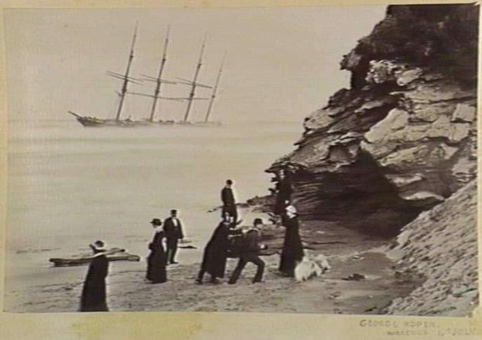
The “George Roper” was a 300ft (91.76 meters) long four masted iron barque of 2,104 tons. She was built at Liverpool in 1882. In 1883, she arrived off Port Phillip Heads in a strong northerly wind. The “George Roper” was taken in tow by a small paddle steamer when the land became obscured by a thick fog. The tug lost its bearings and the barque grounded on the reef, opposite the green light at Point Lonsdale. Efforts to free her failed. The ship was loaded with a valuable cargo worth £10,000 including iron railings for use in railway construction, malt, distilled liquors, drapery and dynamite.
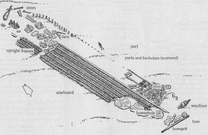
The wreck of the “George Roper” extends to over 83 meters from the large anchor winch at the bow, to the rudder that lies seaward of the Lonsdale Reef. The lower portion of the hull is semi-intact. Parts of the rigging such as masts, yards, backstays and deadeyes lie among the hull remains. Fragments of the cargo including slate, ceramic pieces and clay pipes are strewn about the wreck. This site is best dived at slack-water at the end of the ebb tide.

per DEH
Wreck of the “Holyhead”
6-10M
38 17.720 S 144 36.760 E

The Holyhead departed Liverpool in 1889 with a valuable cargo of merchandise including slate, spirits, chemicals, iron rail and crockery. She arrived off the heads as a squall blew up from the southeast and mist obscured the land. The Holyhead was travelling at seven knots under full sail. She beat back and forth awaiting the pilot and unaware that Point Lonsdale reef extended 100 meters out to sea. She struck and grounded on the reef with seven feet of water in the main hold. Huge crowds gathered at Point Lonsdale and Queenscliff to gaze at the ship with it sails flapping in the wind. The ship eventually broke up and sank. The wreck of the Holyhead now lies seaward of Point Lonsdale reef, 100 meters to the west of the “George Roper”. At the stern, divers can see the ship’s steering gear including its rudder and rudderpost. Some iron hull plating is scattered around stacks of slate and railway iron. A significant feature at the bow is the windlass. The site is best to dive between the end of ebb tide and the start of flood tide.
Wreck of the S.S. “Black Boy”
7m
38 17.78 144 36.91
This 66 ton screw tug was lost trying to salvage cargo from the wreck of the “George Roper” in 1883. A mooring line fouled her prop and heavy seas put her on the reef. She now lies hard against Mushroom Rock, upside down and broken up. Machinery and fittings can still be seen. The area must be dived at slack water during exceptionally calm weather. This site is more exposed to the current than even the other wrecks.
Wreck of the barque “Gange”
7M
38 17.72 144 36.99

The 1071 ton sailing ship went on the reef while trying to enter the heads in 1887. The wreck lies 100m east of the “George Roper” and close to the “Black Boy”. The two wrecks are partly mingled. Noticeable items are the barrels of concrete that have solidified in the centre of the wreckage. The area must be dived at slack water during exceptionally calm weather.
Wreck of the “Glaneuse”
2-4m
38 17.59 144 36.75

The 482 ton barque was ton a voyage from France with a cargo of mostly alcohol. She went ashore at night while waiting for the pilot. The wreck remained intact on the reef for some years before disintegrating. The wreck lies close to the shore 100M west of Point Lonsdale light. Often the wreck is sanded over except after heavy storms. The area must be dived at slack water during exceptionally calm weather following northerly winds.
Castle Rock
12-19mtrs
Castle Rock is a large lump of rock at Point Lonsdale on a limestone and sand bottom. The top rises to 12 meters. The site has lots of nudibranchs and yellow zoanthids. There are of undercuts at the bottom. Large black bull rays, Blue Devil fish, boarfish, old wife, dusky morwong, weedy sea dragons and sweep. Good weather is needed.
Lonsdale Wall
Depth: 6 – 45 metres
Located on the Lonsdale side of Port Phillip Heads, the Lonsdale Wall is a vertical drop-off that extends for 1 km and provides great, but challenging, dive locations. The wall has giant bryozoans, big zoanthid patches, jewel anemones and sea whips. The wall bottoms out at 90 metres if you are a trained tech diver, or have a death wish. Boarfish, blue devilfish, nudibranchs, sea spiders, perch, morwong and many varieties of reef fish.
Foggy Reef
8-30mtrs
(WGS84) 38 17.674 144 37.528
Foggy Reef is at the southern end of Lonsdale Wall. It can have poor visibility on an ebb tide and is exposed to the swell from Bass Strait. The kelp bed on top of the ledge is around the 13-15M. Over the edge is a series of ledges dropping down into moderately deep water. The ledges are full of soft corals, sponges, shrimp, starfish and sea squirts. The fish life includes rock cod, moray eels, Blue Devils, Magpie Morwongs, Boarfish, Old Wifes and Leather Jackets. Best dived on the ebb slack when the incoming tide brings divers back into the bay rather than taking them out to sea.
Spectacular Reef
15 – 45 metres
(WGS84)38 17.335 144 39.786
This spectacular wall in the South Channel was once an old channel of the Yarra River. The area is used by big ships so you will need to co-ordinated dives with the port authorities and get a permit. The area is large and offers many dive sites. Big walls and crevices are found especially between 15 metres and 30 metres. Good marine life can be found along the wall including soft corals, sponges, Silver Trumpeter, Leatherjackets, rosy Wrasse, barber perch, banded sweeps, short fin pike, Trevally and White Ear. This area is more suited to experienced dive parties. It can only be dived on the slack water.
Shortland Bluff
14-21M
The area off Shortland Bluff provides numerous dive sites which have been given various names such such as Torpedo Reef, Albatross Wall, Bommies, Three Trees and Big Bommie. The area has many abandoned old anchors, swim throughs, walls and large Bommies. Many have beautiful growths of zoanthids, soft corals and sponges. Fish include blue devils, Rock Cod, morwong, wrasses, barber perch, banded sweeps and short fin pike under the ledges.
Cottage-by-the-Sea Reef
7- 8m
The Reef lies 50m from beach and consists of a 4m high rock wall that runs for hundreds of metres. Seadragons, cuttles and blue devils are found. On an ebb tide the area is usually sheltered from the strong local currents. The area is best in northerly or westerly winds.
The Springs, Point Lonsdale
8m
This shore dive is reached via a road behind the caravan park and oval. Bluestone stairs next to the boat ramp lead to a small kelp-covered reef. There is some marine life in the area including flathead, seadragons, old wives, draughtboard shark, fiddler rays and zebra fish.
Wreck of the “Wyrallah”
13M
38 18.13 144 37.93
The 206 ton, 40 metre long, steel trading vessel “Wyrallah” was heading to the Gippsland Lakes in 1924. In a heavy squall she passed out of the Heads and was hit by the “Dilkerra” and nearly cut in half. She sank in the middle of the “Rip” and six people drowned. The remains were a hazard and were demolished with explosives. The wreck is heavily scattered and in an exposed, tide swept location that needs perfect weather.
Nepean Wall
Depth: 16 – 35 metres
Nepean Wall is a slightly smaller and shallower version of the Lonsdale Wall. Similarly it is an experienced diver’s dive to be undertaken only during slack water in calm weather. Caves and ledges are found along the wall packed with sponges, sea whips, bryozoans and gorgonians.
Wreck of the “Empress of the Sea”
5-7 meters
38 18.140 S 144 39.300 E

per DEH
This 2200 ton, 240ft long, wooden three masted sailing vessel was built in Boston, USA in 1853. In December 1861, the “Empress of the Sea” was moored at Portsea and when it caught fire and was destroyed.
The wreck was rediscovered in 1984, 700 meters offshore from Nepean Bay. The remains consist of scattered timbers, iron water tanks, chains and anchors. Two large mounds of bluestone ballast lie to the north and south of the site. The site covers an area 150 meters long and 50 meters wide. The bow points southwest.
The site can be subject to strong tidal flow and as the wreck site is large and spread out, a good way of exploring it, for experienced divers, is on a drift dive. For variety, to the south of the site is an area of shallow reef.
Corsair Rock– Wreck of the S.S. “Australia”
5-7M
38 18.10 144 38.62

This prominent rock is about a metre below the water in the most dangerous part of the Rip and must be dived in calm weather and at slack water. Even then it is usually a short dive as the current changes suddenly and quickly builds up speed. There are a number of heavily broken up wrecks in the area.
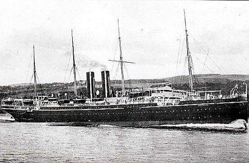
This large 3700 ton P&O liner was launched in 1892. In July 1904, she hit Corsair Rock due to the poor eyesight of the pilot who was trying to take her through the Heads. The wreck was high and dry on an even keel but could not be refloated as the rock had ripped the bottom out of her. It was two years until storm finally shattered the wreck. In 1911, the remains were blasted to clear the boat channel between Corsair Rock and Big Rock. Salvors used explosives again in the 1960s.
The huge propeller and engines remain along with her boilers. The rest has been pulverized into fragments by the swells. A dive at slack water usually only lasts for 30 minutes due to the unmanageable speed of the currents.
Corsair Rock – Wreck of the S.S.”Time”
5-8M
38 17.79 144 38.77
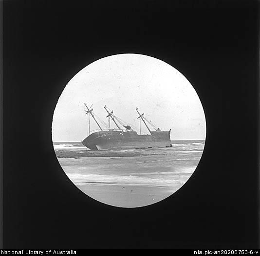
This large 3316 ton steamer also hit Corsair Rock in 1949 after a steering failure. She remained intact for ten years before finally breaking up. She was also blown up by salvors in the 1960s. The wreck lies NW of the Rock Beacon and is widely scattered. The boilers can still be identified. The wreck is renowned for great fish life. She must be dived at slack water and the dive times are short due to strong currents. Calm weather is also a necessity.
Rip Drift
20m
“The Rip” area can be one of the most dangerous waterways in Australia and diving is limited by the tides. One way of harnessing the power of the tide is a drift dive, but it takes experience, surface marker buoys, and an attentive lookout. Charter operators sometimes offer these drift dives. The currents in this area can reach speeds in excess of 5knots which it is impossible to swim against. The currents will usually carry a group several kilometres during a 30minute dive. At 20M there are large and tantalising bommies and deep gutters, teeming with marine life. Care must be taken not to snag the float line on rocks. The terrain rushes by fast until the wall veers to the right and changes into kelp gardens where the now scattered buddy groups can be collected, very exhilarating.
Ripbank
15 – 60m
The Ripbank is an extension of the Nepean Wall. Again it is in a very dangerous part of the Rip and must be dived in slack water. The reef top is covered in kelp and fish life. Deeper down there is good invertebrate life and lots of blue devilfish. On the western end of the Ripbank is the “Playground” which bottoms out at about 50 metres, so monitor your depth. This area has small caves with abundant fish life and is rated as one of the best dives in Port Phillip.
