Back Beaches

Every account of the back beaches contains more warnings than dive information. That’s so you don’t get the impression that just because they are accessible as shore dives, they are easy. Very experienced divers can struggle here even in moderate weather and a new skill has to be learned, “surf entries”, just to access the back beaches.
Nearer the Rip, there are also dangerous cross currents just for further excitement. The weather is also changeable with a safe entry point quickly turning into a dangerous exit. Scout out a few alternatives beforehand and leave plenty of air in reserve for an unexpected long swim to a safer exit point. It is no place for beginners, or the unfit.
These sites can be dived by boat, but this method isn’t entirely safe either. The incessant southerly swells will roll in even on a calm day. Several days of northerly wind is needed to calm the seas and even then freak waves can occur.
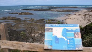
This area has taken a steady toll of people, the most famous being Prime Minister Harold Holt, after whom the nearby marine reserve is named.
Because it is hard and rarely done, it has an attraction for divers seeking a challenge. There are a large number of shipwrecks, all heavily broken up. The rocky bottom is also heavily eroded with crevices for quite good fish life.
Flinders Reef , Back Beach
5-8 mtrs
WGS84 – S 26′ 54.480 E 153′ 29.190
There is a large reef section near the golf course starts quite close to shore. There is a sandy passage out to the main reef area and the whole thing forms a T shape which offers some shelter during entry. This section of the reef is renowned for plenty of fish, wrasse, scalyfin. The area is exposed to heavy southerly swells with summer and autumn providing the best weather. There are reefs 500 metres from shore for fitter and more experienced divers, but save some air and energy for the return journey.

The Blowhole
3-10m
This area has the only shore access to the back beach between Cape Schanck and Flinders Reef. The turnoff is difficult to find 100M east of Razorback Road. A cave cuts through the headland at sea level and in big seas creates an impressive blowhole. The reefs and bommies lie off the headland and to either side along the shore. The whole area is very exposed to southerly swells and very calm conditions are required for safe diving.

Cape Schank
5-15mtrs
This spectacular eroded promontory is a popular tourist feature on the Mornington Peninsula. It also offers limestone reef diving. There is a good cross-section of weedy reef fish life and small invertebrates. Easy and relaxing in good weather. There are numerous small caves and overhangs off the point.
The rougher shores on the western side are rarely visited but have many crevices and some spectacular small sea caves. “The Arch” area includes a smooth sided underwater cave hollowed out by the swell. This cave area boasts rock walls covered in marine life. Another feature is the “Shark Cave”, usually full of Port Jackson sharks. This dive can only be done in very calm conditions and is unsafe in any swell.
There is also lots of medium depth reefs (15–25 m) offshore from Cape Schanck. This area consists of rubble and bedrock covered by sand. On more secure rocky areas there are large kelp gardens. In even deeper depths there are even larger reefs, pinnacles and canyons that support lots of colourful sponges, sea tulips and lace corals.
According to Underwater Victoria, the deep reefs, canyons and pinnacles off Cape Schanck are of high conservation value, but they have not yet been properly surveyed and are not currently protected.

Number Sixteen
5-8M
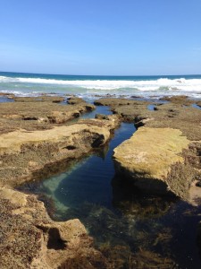
This area consists of a series of low ledges and gullies off the edge of the sea terrace. There are some nice undercuts full of fish. The platform is rent with wave worn crevices some of which are big enough for a diver to enter and contain blowholes exiting at the surface. They are very dangerous and a freak wave can force you through and against the rocks in a potentially fatal way.
Wreck of the “Craigburn”
6-8M
38 23.67 144 47.15

In 1891, the 2065 ton vessel was being towed out through Heads by the tug “Rescue” when the tow line broke. Attempts to get another line failed. The cantankerous and drunk old Captain refused to pay 500 pounds for a tow, and after arguing with the pilot, had to be locked up below. The tug “Eagle” threw over a line but a drunken crewman refused to work the winches without the captain’s orders, and the tow again parted. The vessel dragged her anchors and struck on the Rye Back Beach off “The Divide”. Six men drowned. The wreck is very scattered in an area remote to boat access. On a great day she can be dived but you need a good lookout for freak swell and sudden weather changes. There are also large bommies near the wreck that are a hazard to navigation.
Pearses Beach
5-10M
Large rock pools and gullies have some interest and lie close to the shore. For deeper sites, the nearby Prickly Rocks provide access to further ledges and crevices to the west. This area tends to be slightly less wild access than the rest of the back Beaches, but not by much.
Bridgewater Bay
4-8m
This are is similar to the Pearses Beach area and is accessed via St John’s Wood Rd. To the east there is a prominent sea cave at sea level called the “Bridge”. There are nice ledges off this feature.
Spray Pt Caverns
5-15M
The deep undercuts off the sea terrace are known as the “Caverns”. This point is more prominent than others in the area and seems to get rougher and is more exposed to currents. This has increased the erosion along this section of the coast, making for interesting reefs, but they are for very experienced divers only. The reefs go a long way offshore, and the outer reefs are more easily dived by boat in very calm weather.
Bay of Islands, Diamond Bay
4-7m
This area offers some of the best shore diving on the Back Beaches. In calm weather the gullies and crevices around the islands can be explored. It’s a long area to cover with a lot of scrambling over shallow platforms to reach distant gullies. It is suitable for the fit only, even in good conditions.

St Pauls Rk And Jubilee Pt
5-7m
This area has some sheltered access points to many ledges. The reefs have very good fish life and some interesting small caves near the sea terrace.
Sorrento Back Beach, Sphinx Rock
3-7M
This is accessed over a popular swimming beach with good shore diving around the sea terraces. At low water in good weather, a walk along the coast gives access to the rarely dived Sphinx Rock.
London Bridge
5-7m

This natural arch in limestone lies one kilometre west of Portsea Back Beach and is a popular tourist spot. The area is the last accessible point on the Back Beaches before reaching the former Army land at Point Nepean. The shallow bay to the west has interesting gullies and good marine life, but only on exceptionally calm days.
Wreck of the “Sierra Nevada”
3-7M
38 19.79 144 41.25

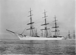
The 233 foot long Sierra Nevada was built in 1877 at Southampton, England. The vessel was a 1470 ton iron sailing ship. The Sierra fleet consisted of fourteen grey-painted fully-rigged ships. The ships were mostly built for the Rangoon rice trade. In 1900, the vessel arrived off Port Phillip Heads in rough weather. She had 2,600 tons of general merchandise for Melbourne. While waiting for the pilot schooner the ship was driven on to the reef near London Bridge. The Sierra Nevada rapidly went to pieces in pounding surf with the loss of 23 of the 28 crew.
The site lies in the wave zone about 150M from shore off a small beach on the Fort Nepean side of the old boundary fence. The bow is still visible although the rest of the wreck is scattered and sometimes sanded over. The area is very wild and is rarely dived as it needs exception conditions.
Wreck of the “Cheviot”
1-4M
38 18.84 144 39.85

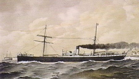
The S.S. “Cheviot” was built at Newcastle upon Tyne in 1870. She was 230 feet long and 1226 gross tons. In 1887, the S.S. “Cheviot” was on her way to Sydney with cargo of food, wine and metals sundries. After passing through the heads she suffered mechanical problems with the propeller. A south westerly gale was blowing and the “Cheviot” struck the shore. The lifeboat could not make it through the heads in the gale. Some passengers drowned before help arrived and it was Victoria’s worst shipwreck with the loss of 35 lives.
The wreck is heavily broken up and then blown up by salvors in the 1960s. Much of the wreck is in very shallow water and wreckage can be seen at low tide. The area is close to “The Rip” and can experience occasional cross currents, big swells and turbulence.
Wreck of the “Formosa”
3-5M
38 19.64 144 40.90
The 205 ton steamer was on her maiden voyage when she ran aground at Portsea Back Beach in 1869. The vessel is shattered and spread over numerous gutters. The boilers and winches are still identifiable. The wreck can only be dived in ideal conditions.
Wreck of the “Petriana”
3-5M
38 18.63 144 39.34

Australia’s first major oil spill occurred in 1903 when the “Petriana” was lost. She was an 1,821 ton bulk oil carrier. The heads were shrouded in fog and even with a pilot she went up on Portsea Back Beach. Within moments the engine room and stokehold were flooded leaving the vessel without power. To lighten the vessel they released 1300 tons of oil into the sea, “a film of great beauty, radiating all the colours of the rainbow, spread from Sorrento Back Beach to Point Nepean”. The foul-smelling oil contaminated the beaches. The attempt to refloat her failed.
The landing of the Chinese and Malay crew caused a storm of controversy as the White Australia Policy then prohibited non-Europeans from entering the country. The Australian Prime-Minister at the time, Alfred Deakin, backed up the local authorities. Captain Kerr wrote, “If this treatment of my crew is a fair specimen of your humanity it is about equal to the worst barbarity of other nations, and if it is forced on you by your laws, I regret to say they are a disgrace to the British Empire”. The wreck of the “Petriana” still lies in shallow water in pieces around 200m off Point Nepean. She is so close to the Heads the site is influence by cross currents and is swelly and surgy. The wreck is very scattered, but the bow is relatively intact in 3M, pointing towards the shore. The wreck can be heavily sanded over at times.
