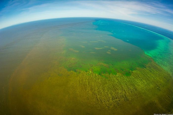
Massive plumes of polluted floodwater are drenching the Great Barrier Reef.
The recent Queensland floods have seen muddy waters fanning out from swollen rivers of North Queensland.
The flood run-off is reaching the outer-shelf reefs 60 kilometres from the Queensland coast. The flood comes soon after a series of mass bleaching events.
 The plume from Burdekin River is shown inundating Old Reef in the central Great Barrier Reef. (Supplied: Matt Curnock JCU)
“The two things we’re mostly concerned about is sediment from erosion in the catchment that gets transported with rainwater into the rivers out onto the reef and nutrients such as nitrogen and phosphorus,” Dr Kroon of JCU said.
Dr Kroon said the flood debris could potentially kill coral and seagrass if it lingered long enough, but it was not yet clear whether that would happen.
An AIMS reef water quality monitoring team will soon report on how coral is coping.
But the unexpected influx of cooler floodwaters and prolonged cloud cover could mitigate the risk of underwater heatwaves baking the stressed coral, Dr Kroon said.
“The reef doesn’t even really get time to recover from any of these disturbances because it gets hit with something pretty much every year.
“It’s not catastrophic … but it is still an extraordinary event because we see flood plumes reaching definitely to the mid-shelf reefs and in certain areas to the outer reefs.”
The only other flooding event in modern memory with comparable scale to impact on the reef was from Cyclone Oswald in 2013, Dr Kroon said.
Tackling water quality is the focus of government efforts to protect the reef, with coral degradation through run-off being a key threat after climate change-driven sea temperatures and acidity.
Flood plume samples would be analysed in coming months and give clues about which areas onshore should be targeted to stop run-off.
“What we’re doing is trying to capture sediment in the flood plume itself and then trace that back to its source within the catchment,” she said.
“Basically what we’re trying to do is help prioritise, within the catchment, where erosion control works would occur, and we’re using the physical and chemical properties of the sediment to trace it.”
