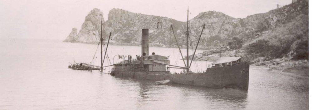
Leeuwin-Naturaliste (Ngari Capes) Region,
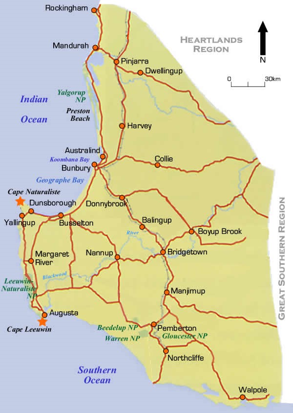 The Leeuwin–Naturaliste area is still within range of a long day/weekend trip from Perth and offers a slightly different experience along a very spectacular granite coastline. The coastline between Busselton and Cape Leeuwin consists of a narrow continental coast facing the often wild Indian Ocean. The rocky headlands along the coast are fringes with weedy reef and interspersed by long, sweeping beaches. The beaches in the area are popular with bathers and surfers. Some spots are more sheltered and here the fishlife is boosted by productive temperate seagrass meadows, especially in the shelter of Cape Naturaliste. In W.A. these seagrass beds are second only to Shark Bay in size and can thrive in 40 metres of water. The South West capes area is one of the most diverse temperate marine environments in Australia. Warm, tropical waters of the Leeuwin Current mingle with the cool waters of the Capes Current, resulting in high fish diversity, including tropical and temperate species. Significant numbers of marine mammals also frequent the area, including the blue whale.

Geographe Bay
Bunbury
The port of Bunbury is Western Australia’s third largest city after Perth and Mandurah. It is near the mouth of the Collie River at the southern end of the Leschenault Inlet, which opens to Koombana Bay and the larger Geographe Bay that extends south to Cape Naturaliste.
Wreck of the “Lena”
18M

The 55m Russian-registered, long-line fishing vessel was confiscated by HMAS “Canberra” for illegally fishing for Patagonian toothfish in 2002. The Bunbury Chamber of Commerce and Industry successfully bid for her and scuttled the vessel as a dive wreck. The Lena is 5km off the Bunbury coast on a sandy bottom and is a big, photogenic and currently intact vessel. Lena has large open internal spaces with three or four exits. It takes around 45 minutes to explore the entire ship and the area often enjoys good visibility. Chairs, a fish processing plant, the main engine, generators and propeller have been left in place. Permits are required to dive the wreck and is generally dived through local dive shops.
Wreck of “Mary”/Lockeville Jetty
GPS position: Lat. 33º 37.08′ S Long. 115º 24.65′ E
The Western Australian Timber Coy was a syndicate of Victorian investors, who in 1870 were granted 181,500 acres adjacent to Geographe Bay. They established a mill and jetty at Lockeville with a 3ft 6in gauge railway running inland to their timber station at Yoganup. The Mary was a 65.6 ft wooden schooner built at Fremantle in December 1868. On 4 June 1879 the Mary was tied up alongside the jetty at Lockeville (now a ghost town 2 km NE of Wonnerup), but as the weather worsened the schooner was hauled off and moored to the West Australian Timber Company’s mooring about 180 m from the jetty. By 2.00 a.m. the following morning the heavy seas were breaking over the vessel, which dragged the mooring. The Mary hit a jetty pile and then went broadside on to the jetty and ended up on the bottom in shallow water. The remains of the wreck of the Mary lie close to the jetty piles, about 40 m from the shore. The wreck was relatively intact in the 1970s but is now mostly buried or has been dispersed. It may be uncovered from time to time in the future. A dive for the rabid wreck explorer.

Busselton Jetty
8M
This is the second longest wooden jetty in the southern hemisphere. Best area to dive is about the last 300mtrs of the jetty, but it is 1.8kms long and dive access from the jetty isn’t always assured. The simplest method of getting out is a boat, you don’t need anything huge as it’s very protected and the ramp is right next to the jetty. This is touted as a one of the top 40 dives in the world”, well jetty dives, maybe. The Busselton Jetty Underwater Observatory allows non-divers to enjoy the colourful reef and sea life under the jetty, once accessible only to divers. The observatory is 1.8km off-shore and is reached by train. Up to 40 people at a time can be accommodated 8m below the surface. They will see amazing corals and fish through 11 viewing windows at various levels within the 9.5m-diameter chamber.

Wreck of the H.M.A.S. “Swan”
20-31M
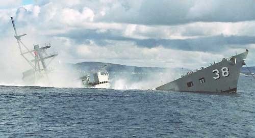
The former destroyer HMAS Swan was scuttled to form a dive wreck and artificial reef in December 1997. The Swan is over 113 meters long and over 20 meters wide. The tower of the vessel is just six metres below the surface with her base at 31 metres. The average visibility in this area is 18-25M and even then you can’t see the wreck from stem to stern. One dive is not enough to fully explore the wreck. The wreck still has a grey naval ship look about her with the marine life only slowly colonising the structure. The wreck is fairly safe for penetration as holes have been cut in the hull to make light visible from inside the compartments. She has a light dusting of silt and is starting to be covered in soft coral. The fishlife is often good with batfish swimming around the Crow’s nest, where divers do their deco safety stops. Large schools of Bullseyes inhabit the rooms, with King George whiting. samson fish and dhufish schooling over the wreck.; The hull is patrolled by bream, Shaw’s cowfish, blue devil fish, sweep, and talma. A 500 meter exclusion zone has been established around the site, which prohibits any fishing or hunting. Permits are required to dive the ship and as she can be very popular in summer, bookings are essential. The vessel is often done as a day dive from Perth as it only takes 2 hours to drive to Busselton.
Naturaliste Reef
50M
This area is hard to get to with big drop-offs and excellent fish and marine life. Its 20 nautical miles offshore and rarely dived as most of the local deep diver effort is now focussed on the Swan wreck.
Eagle Bay
2-3m

This is a great spot for a family snorkel and is so shallow you can easily encounter the areas small marine animals without even having to duck dive. The sand and boulder bottom has plenty of seagrass that is home to plenty of small fish and molluscs. It’s sheltered from the afternoon breeze and usually flat and relatively clear. The granite rocks of the bat are picturesque and it is also a great picnic spot.
Coral Bommies
7-15M
For more experienced divers a 300-400 metre swim offshore of Eagle Bay is rewarded with a line of offshore granite reef. This reef is home to a more diverse array of fish and marine life. These pinnacles and ledges boast good marine life and lots of pelagic fish. Location is guarded by the locals. There are other little-known or visited reefs in 17-23M, 8 and 11 kms from shore, but a larger boat is needed as they sit outside the shelter of the bay.
Gannet Rock, Dunsborough
3-4M
This small rock lies close to Eagle Bay and is accessed by an unsealed track which comes off the Eagle Bay – Meelup Road. The rock is an 80 metre swim from shore and offers a good array of small marine life and some nice fish. The rock is usually covered with anglers and the bottom with their lost gear. This rock ids great for a snorkel or night dive and is usually very protected.

Bunker Bay – Shelley Beach
5M
This involves a short swim out from Shelley Beach to some reefs on the seaward side of a small offshore rock about 60M offshore. Along the way there are stingrays, bream, sweep and other fish. Around the large rock there are plenty of fish including schools of moonlighters and stripeys. Coralfish, red-lipped morwong and prettyfish can be found around the ledges. There is also plenty of good snorkeling and diving in the rocks and reef all along this shore out towards West Point.
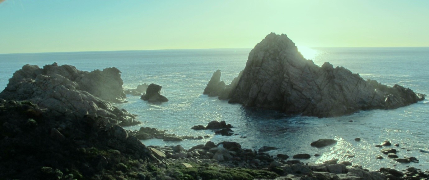
Sugar Loaf Rock
17-22M
Good snorkelling can also be had in the shallows where smaller fish can be seen on weedy reef. Only entry and exit over the rocks and gravel is difficult. Boat access to nearby deeper reefs is possible from the adjacent boat ramp. The area is very exposed to the swell.
Smith’s Beach
Snorkeling is good around the rocky areas. For scuba divers with a boat there are reefs a few hundred metres from the beach. These have good fish life and the marine life is quite pretty too.
Canal Rocks – The Honeycombs
6M
This involves an energetic 400M swim in a north easterly direction along the shore from the Canal Rocks boat ramp (watch out for boats and show a dive flag). Near the shore you will often encounter stingrays that aggregate near ramps to scavenge fish scraps. After a long swim, limestone reef begins to appear and The Honeycombs appear as a series of ledges and caves in a large limestone outcrop. If all you can see is a large expanse of sand you have gone too far.
Canal Rocks
5-20M
The point off Canal Rocks can be accessed by boat, although some hardy and experienced will try it from the shore. There are a series of nice limestone reefs heading out to sea from the tip of the point. Access is via the Canal is very low seas although in any swell it can be very rough and surgy. Alternatively divers can swim the long way around on the sheltered north side near the Boat ramp. It sounds like a boat would be a lot easier and safer. The outer side of the rocks drop into a sponge garden patrolled by pelagic fish. There are gutters full of fish and invertebrates including blue grouper, dhufish and harlequin wrasse.
Indicators
20-30M
This site is well offshore from Canal Rocks offering spectacular walls and caves rich with marine life and fish.

Cowaramup Bay
2-25M
1.5kms off the little seaside resort there are deeper reefs. The shallower inshore area is can also be done as a shore dive in very calm weather with western blue groper, occasional kingfish, blue morwong. Access to the reefs around this area is provided by a ramp at Calgardup Beach/Prevally park, 15 kms to the south.
Georgette 1876
This Fremantle–owned 211 ton, 46 metre schooner-rigged iron steamer got into difficulties on December 1 and ran ashore at Calgardup (Redgate Beach), north of Hamelin Bay. The wreck was seen in the breakers and the survivors assisted ashore by Aboriginal stockman Sam Isaacs and the l6-year-old Grace Bussell. Seven lives were lost when a lifeboat was launched before Georgette came ashore. The wreck was found in 1964. The wreck is only infrequently exposed above the sand and is very expose din big seas. The shallow inshore reef also makes for a good snorkel.

Kilcarnup
6M
You need a 4WD to get to this site which consists of a heavily limestone reef. The track will bring you almost to the sea, but there is still a steep walking track of 50M to get to the water. The shape of the reef means that it offers s bit of protection from westerly weather, although the visibility improves after a few days of calmer conditions. The reef is home to a variety of fish and other marine life. It also makes for a good snorkel or night dive. The inshore side of the reef offers some small marine life to appreciate or photograph including blue devilfish, old wife, scalyfin and wrasse. Morwong, groper and buffalo bream tend to be encountered further from the shore.
Hamelin Bay,
If you are planning to dive around the Hamelin Bay area a boat will be necessary as all the reefs are several hundred metres from the beach. A 4WD may be needed as the ramp is narrow, slippery and exposed to the swell. The beach offers a caravan park and one of W.A.’s oddest natural encounters. Large stingrays have been encouraged to come close to shore in large numbers and can be hand fed. Despite being distant and somewhat exposed, the area is popular during summer, with the result that the numbers anything edible crays, large fish, or abalone have plummeted recently. The declaration of Ngari Capes Marine Park has not resulted in this area falling into a no fishing zone, so this is unlikely to change.
Hamelin Island
9M
The sheltered reef flat on the lee side offers nice ledges and small caves. Prettyfish, bullseyes and puller can be seen near the ledges while schools of buffalo bream, old wife, herring, and pike patrol the area. Darting in around the weedy reef are foxfish, leatherjackets, moonlighters and wrasse. There are also a few gorgonia sea fans and colourful sponges in more sheltered crevices.
Hamelin Island – NE Bommie
9M-15M
This area is accessed by boat in good weather and consists of a large 50x50M bommie with quite a few submerged caves and swimthroughs. The structure encourages more delicate marine life and planty of fish. There are the usual reef fish as well as breaksea cod, slender wrasse, western king wrasse and banded sea perch. Harmless Port Jackson sharks and stingrays also laze around on the bottom of some sea caves.
Wreck of the “Cumberland”
3-8m
In 1829, this 444–ton wooden colonial trader was wrecked on a sandbank south of Cape Hamelin while loaded with coal and cattle. She was en route from Newcastle NSW to Fremantle. There was no loss of life. Anchor, cannon and timbers are there but the bottom is weedy and the relics can be hard to see. The wreck was found by divers in 1981. Material from the wreck is on display in the Augusta Museum.
Wreck of the “Agincourt”, Hamelin Bay
5-6M
GPS Lat. 34° 12.8741′ S Long. 115° 02.0196′ E
The 131.9 ft (40.2 m) wooden barque “Agincourt” was launched at Sunderland, UK 1863. The “Agincourt” had arrived in Hamelin Bay on 17 February 1882 from Adelaide and loaded with timber. She dragged the anchor in heavy weather and went aground 30 m from the beach. The Agincourt is situated 900 m north of the boat launching ramp at Hamelin Bay, and 120 m offshore. It lies just south and inshore of Inside Rock on a sandy bottom with bows towards the beach. The lower part of the hull is intact and there is part of the cargo of stacked timber sleepers still in the hull. Five metres closer inshore there is a section of the upper hull, with seven chainplates still attached. An iron water tank lies between the hull sections.
Wreck of the “Chaudiere”, Hamelin Bay
5–6 m
The “Chaudiere” was built at Sunderland in December 1863. The “Chaudiere” arrived in Hamelin Bay on 23 May 1883 to load sleepers. A storm put her on the shore and she was wrecked. The wreck lies 650 m north of the Hamelin Jetty, and about 300 m off the beach. The wreck lies on a sandy bottom in water, bow towards the shore. There are the remains of planking and frames. Some iron fastenings protrude from the sand in the midships area. A conspicuous cargo of sleepers are also visible.
Wreck of the “Katinka”
5-6M
One of the most severe storms to hit the South-West occurred in July 1900 while several ships were at anchor at Hamelin loading timber. The force of the wind was such that the Katinka dragged the timber company’s mooring, consisting of three anchors each over 2 tons in weight. With the rest of the crew clinging to the foremast the vessel drifted northwards, where it struck about 450 m from shore. These men clung to the rigging until they were rescued the following morning. The bow section of the Katinka is standing almost upright and lying on a north–south axis, parallel with the shore and with the iron bowsprit pointing south. To seaward of this is a large windlass, while a small anchor lies inshore of the wreck. The stern section is buried deeper in the sand bottom, although parts of it project up to 1.5 m above the sand.
Peak Island & Wreck of the “Toba”, Hamelin Bay
7-15M
Peak Island is the island to the left of Mushroom Rock as you look straight out from the Hamelin Bay boat-ramp. The diving here is on weedy limestone reef with lots of fish life. On the southern side there is small wooden ketch was built in the Aru Islands in Indonesia in 1907. Clark & Co. owned over 200 schooners and luggers, most based at Thursday Island and Broome for pearling and fishing. The “Toba” ran ashore in 1933, and sank close to Peak Island. The wreck of the “Toba” lies against the sloping reef in 7.6 m of water. The wreckage includes some timber frames, ballast stones and a windlass.
Mushroom Rock
6-15M
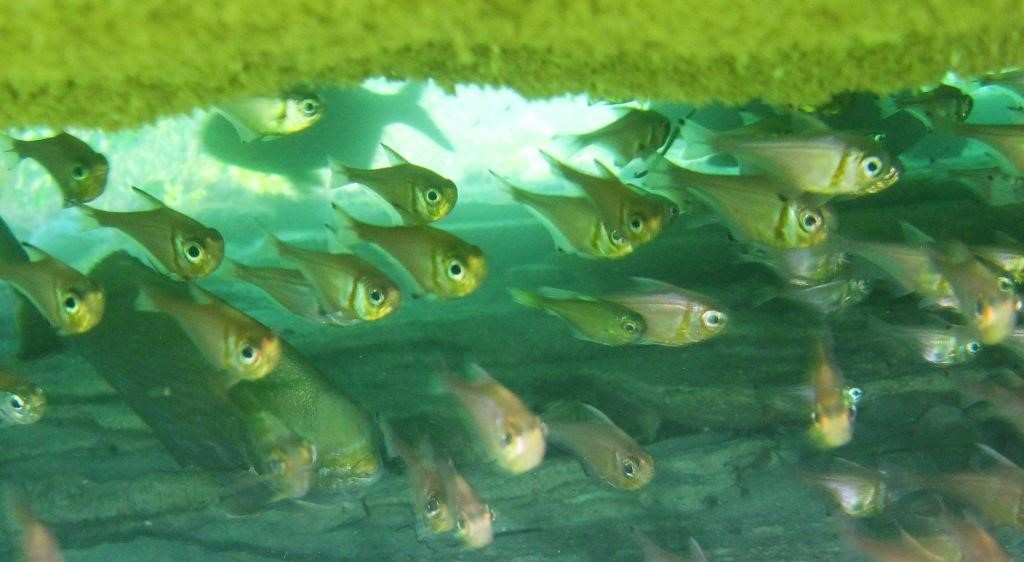
This rock is easy to reach as it is a moderately stiff 200M swim from the boat ramp. A small overhang is encountered and on the western side a series of narrow channels packed with marine life. The reef has good fish life, as with much of the area and is patrolled by buffalo bream, old wifes, puller, scalyfin, morwong, herring, wrasse and leatherjackets. An overhang on the north western side also has quite a few colourful invertebrates including cuttlefish and gorgonia.
Mushroom Reef
8M
Mushroom Reef can be found in between Mushroom Rock and Peak Island. This reef is similar to many in the area being good for fish life and not too difficult in good weather. It also has a narrow crevice that cuts through the island and is packed with marine life. This is a bit too narrow and would be dangerous in a swell.
Cosy Corner offshore reefs
There are a number of small islands offshore surrounded by reef. The lee side of these islands offers good diving in suitable weather. These reefs are more easily accessed via Hamelin Bay boat ramp than as shore dives. The reefs offshore have a lot more fish than inshore sites with schools of buffalo bream, black-headed puller, coralfish, old wife, herring cale, trevally, banded sweep and zebrafish.
Cosy Corner
7M
Cosy Corner can be found by turning on to Cosy Corner Road, which is about 11km from the southern end of Caves Road, just outside Augusta. Just off the beach there are some reef platforms close to the shore. Beware of the steep hill leading down from the car park when fully loaded with gear. The overhangs are full of smaller fish including scalyfin, blue devils, morwong, foxfish and harlequin fish.
Skippy Rock
This small sheltered south-facing beach forms the southern side of the sandy foreland that ties Skippy Rock to the shore. Rocks also outcrop on and immediately off the beach. There is a lookout here and some interesting coastal vegetation. 100 m long pocket of sand wedged between the first two outcrops of the Skippy Rocks. It is fronted by continuous rock reefs and boulders, which lower waves to less than 1 m at the shore. A lagoon mouth causes a permanent rip through the reefs and this area should be avoided. It is otherwise a great spot for snorkelling, or scuba diving. After the dive, check out the local rocks which contain fossilised thrombolites dating over a million years old. Part of Cape to Cape track also passes through this area.
Quarry Bay
A gravel road, off the Skippy Rock Road, leads to a car park at the back of the Quarry Bay beach. The bay is 200 m across at the entrance. Waves break over granite rocks and reefs strewn across the mouth resulting in lower wave energy at the shore. The reefs near this beach are usually suitable for snorkelling in calm weather. At the south end of the bay, limestone was hewn for the blocks used to build the Cape Leeuwin Lighthouse. The area makes for a good snorkel dive.
Wreck of the S.S. “Pericles”, Off Cape Leeuwin
35M
GPS position: Lat. 34° 25.33′ S Long. 115° 08.24′ E
 The “Pericles” was built by Harland and Wolff, Ltd in Belfast for the White Star Line and launched in 1907. It was an iron steamer of 10 925 tons. The two quadruple expansion engines produced a speed of 14–15 knots. The Pericles was en route to London with a large mixed cargo of butter, mutton, wool, hides, apples, tallow, coconut oil, lead and other items. On 31 March 1910, the steamer struck an uncharted rock near St Alouarn Islet, 6.5 km south-east of Cape Leeuwin. It passed over the rock, but the damage to the forward plates was so great that within three minutes there were 5 m of water in the forward hold. The lifeboats were all got away before the ship drifted before going down by the bow 5.6 km south of the Cape Leeuwin lighthouse. The large wreck site is a large jumble of wreckage, dominated by three large boilers and the port engine standing upright. The area is noted for big currents. Today the wreck of the “Pericles” lies in sight of the Cape Leeuwin lighthouse, but is generally inaccessible to the recreational diver due to the strong currents and swells which naturally occur where the Indian and Southern Oceans meet. She is rarely dived by a few hardy locals and maritime history enthusiasts.
